“Loving Island Life” Springtime on Bainbridge Island
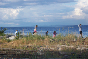
 This weeks “Loving Island Life Blog” features Springtime on Bainbridge Island. Fruit trees are blossoming, berry plants are budding, and daffodils are everywhere! We are blessed with an abundance of natural beauty, the air is crisp and fresh and though you may still come home with muddy boots, it’s a great time to grab your favorite friend, family member or critter and head out to one of the islands many beautiful parks and over 30 miles of hiking trails. Here is a list to help you find that perfect spot for a picnic, stroll along the waterfront, or to hike, bike or jog your way through March. Enjoy, and we’d love to see photos!
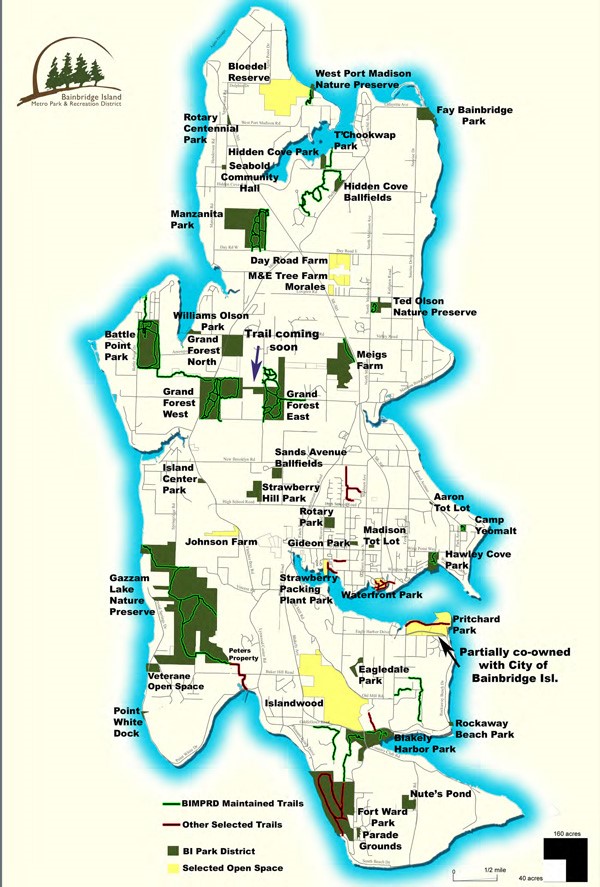
Battle Point Park has 3.5 miles of trails surrounding and throughout the park and is also surrounded by a 1.5 mile equestrian trail. Enter the park from Arrow point Road on the east side, Battle Point Road on the west, or Frey Road on the north, each entrance has parking lots.
Blakely Harbor and Blakely Cemetery Trails. This trail system is located in Blakely Harbor Park former site of Port Blakely Mill, one of the world’s largest sawmills in the late 1800’s. This 40 acre park will be developed for passive recreational use such as picnicking, kayaking, and wildlife viewing.
Currently the site offers a ½ mile trail that can be accessed on 3-T road or off of Blakely Ave. The narrow class II trail winds through the woodlands and reaches the shoreline in several locations.
Eagle Harbor Waterfront Park. This is a small park in downtown Winslow, located behind Town and Country Market. It has a nice playground for the kids, a grassy area for picnics, and a short trail that runs along the waterfront.
Fairy Dell Trail. As enchanting as it sounds, Fairy dell features a .5 mile trail that follows a seasonal stream and winds through some of the oldest trees on the island, including several old growth cedars and Douglas firs. Trail users can expect to be very pleasantly surprised at how remote and private this trail can feel. It offers the trail user the opportunity to get away from the hustle and bustle of everyday life with a short quiet ½ mile walk to the beach along a narrow winding trail from Battle Point Park down to the water near Manzanita Bay, with a view of Puget Sound west to the entrance to Poulsbo’s Liberty Bay and beyond to the Olympic Mountains. It is a great spot to watch seabirds and raptors. The trail head is located across the street from the Battle Point Park parking lot on Frey. Parking is available in a large parking lot on the north side of Battle Point Park. The trail can also be accessed from the beach at the bottom of the trail over a rough rock staircase built by the Park District.
 Fay Bainbridge Park. Located at 15446 Sunrise Drive, Fay Bainbridge Park is a 17-acre marine camping park with 1,420 feet of saltwater shoreline on the northeast corner of Bainbridge Island. The park offers sweeping views of Puget Sound, the Cascade Mountains and features sandy beaches. On clear days, Mount Rainier and Mount Baker are visible from a sandy beach. Shellfish harvesting is prohibited. For information on camping, boating, wildlife and environmental features and all that this wonderful park has to offer visit the Bainbridge Island Metro Park and Recreation District website.
Forest to Sky Trail. The Forest to Sky trail is a .9 mile class I trail that connects the District’s most popular trail system, The Grand Forest to its most popular park, Battle Point Park. The trail was constructed in 2007 after much collaboration between The District, COBI, BI Land Trust, and several private land owners. It features a 100 foot boardwalk across a wetland in the center of the trail. The trail provides a serene walk through forestland and provides the opportunity to get from the Grand Forest to Battle Point and beyond.
Trailheads are located across Miller Rd from The Grand Forest West Trailhead, and in the SouthEast corner of Battle Point Park.
 Fort Ward Park. Fort Ward Park is a 137-acre marine park with 4,300 feet of saltwater shoreline on Rich Passage. Many of the structures in the park reflect the historic military significance of the area, but the park is well developed for day use. There is an underwater park for scuba divers, a two-lane boat ramp and a long, rocky beach along Rich Passage. Come and walk the new ridge trail. You can connect to it from the Fort Ward to Blakely Harbor Trail or out of the Upper Fort Ward parking lot off of Fort Ward Hill Rd. There is also a new trail from the Parade Grounds meadow area that connects to the paved trail which leads to the beach.
For information on camping, boating, wildlife and environmental features and all that this wonderful park has to offer visit the Bainbridge Island Metro Park and Recreation District website.
To get there, take Pleasant Beach Drive south from Lynnwood Center through a residential neighborhood and park in the paved lot by the boat ramp. The steep loop trail is accessed from the parking area across from the water. Or take Belfair Road to the upper parking and picnic area.
 Gazzam Lake Park and Preserve. Gazzam Lake Park and Wildlife Preserve includes 444.6 acres of highly valued upland forests and wetlands in the southwest quadrant of Bainbridge Island. The Park has an extensive trail system.
The initial 318 acres of this exceptional park was purchased by the citizens of Bainbridge Island after a special bond election in February 1995 and the winning of various state grants towards the purchase. It is the Island’s second largest area of undeveloped property. Recent additions to the Gazzam Lake Preserve include Open Space purchases of the 49 acre Peter’s and the 64 acre Close properties, and a the generous donation of an 8-acre parcel by David and Joyce Veterane.
Gazzam Lake, in the northwest part of the park, is a 13-acre freshwater wetland area that has remained substantially untouched by human development, thus providing scenic beauty and wildlife habitat for a variety of species.
A Gazzam Lake Advisory Committee, consisting of 22 interested citizens, was appointed by the Park Board in late 1995. The committee’s mission was to make recommendations to the Park Board concerning the Master Plan for Gazzam Lake Park.
Located between Baker Hill Road and Marshall Road, a quarter mile west of Crystal Spring Drive. Current access to the property is from Marshall Road to the north, and Deerpath Road to the south, off of Baker Hill Road, with very limited parking in both areas.
 Grand Forest. This 240-acre conservancy park complex consists of 3 separate parcels located on Miller and Mandus Olson Roads.
The park contains wetlands, second-growth forests, wildlife habitat and an extensive trail system.
Parking and multiple trailheads are along the east side of Miller Road and on Mandus Olson Road off of Koura Road.
Hawley Cove Park. This 11.7 acre conservancy park contains upland forest, a large wetland, and 330 linear feet of saltwater shoreline on Eagle Harbor. The park has a 400 foot boardwalk and .25 mile walking trail from Wing Point Way to the shoreline on Eagle Harbor.Trailhead is located at the intersection of Wing Point Way and Azalea.
Hidden cove Trail. The Hidden Cove Trail can be accessed on Phelps Rd in the parking area of Hidden Cove Ballfields. The 2 mile class II trail system winds though varied forest and topography within the Hidden Cove Estates. This trails system is owned by the City of Bainbridge Island and maintained by the Park District.
Manzanita Park. Manzanita Park is on Day Road, west 1/4 mile from Highway 305. It is heavily used for equestrian purposes.
The Bainbridge Island Park District obtained Manzanita Park from Kitsap County in 1982.
The property totals 120 acres and contains remarkably diverse vegetation. It includes both walking and equestrian trails, plus parking. Heading west on Day Road, about a half mile from Highway 305, turn right on a gravel road and drive a short distance to an open area for parking. A trailhead marker is visible, or you can walk straight beyond the parking area onto the trail at the north end of the loop toward the horse corral.
Meigs Park. Meigs Park is located at the southwest corner of Koura Road and State Route 305. The 120-acre park includes a complex wetland system of ponds, bogs, and old-growth spruce.
A walking path extends along the upper area of the park, but public access is limited due to the delicate nature of the bog. Future plans call for a boardwalk and an interpretive viewing area to expand public access.
Enter the park from a four-car parking area located on the south side of Koura Road, just off of Highway 305.
Strawberry Hill Park: In 1966 this 25-acre former Nike site was transferred to the Bainbridge Island Park District by the Federal Government. The former barracks building is used as the Park District administrative offices. The former missile assembly building is used as an indoor mini gym.
The park includes three softball/football fields, concession and restroom buildings that were built by Bainbridge Island Pee Wees, Strawberry Hill Center, Mini-Gym, a picnic shelter, tennis court, sand volleyball court, a brand new volunteer-built playground, and a skatepark (partially funded by the Bainbridge Island Rotary Club) which opened in 2001.
Strawberry Hill Park is located on the north side of High School Road between Sands Road and Fletcher Bay Road.
Ted Olson Nature Preserve. Ted Olson Nature Preserve is located on the east side of Madison Ave North between Valley and Winters Roads. The initial 10-acres were donated to the Bainbridge Island Park District in 1973 by Theodore Olson, whose family had owned the property since the turn of the century.
In 1982 members of Scout Troop 565 developed a .3 mile nature trail through the property with help from the Bainbridge Island Garden Club and the Park District. Walkers can follow the trail with the help of a pamphlet, available at the Park District, which describes the plants and trees along the way.
In June of 2010 the 5-acre Kallgren Addition trail was added through the efforts of the Bainbridge Island Land Trust and the Ted Olson Nature Preserve neighbors and friends.
Madison Avenue North. Closest cross-streets: Madison Ave North & Roberts Road
West Port Madison Nature Preserve. West Port Madison Nature Preserve is located on County Park Road and Gordon Lane. Kitsap County transferred the property to the Bainbridge Island Park District in 1988.
This 13 acre preserve is located in a residential area and has two picnic areas with shelters and barbecue pits, nature trails and views of Puget Sound. The park is home to diverse floura and fauna, and is a great place for bird watching.
Address is 8334 N.E. County Park Road. Closest cross-streets: Gordon Lane & County Park Rd. Accessed is off of Highway 305 on West Port Madison Road heading east. Follow it past Smoland Lane to the corner of West Port Madison Road and Country Park Road, where you will see a sign for West Port Madison Nature Preserve and a small parking lot.
For more information about Events and things to do on Bainbridge Island, our Real Estate Market , Bainbridge Island Lifestyle, Condominiums, Luxury Waterfront Homes, Equestrian Properties, and Estates and Farms,visit www.homesforsaleonbainbridgeisland.com. Discover what “Loving Island Life” is all about!
Information for this post was obtained from the Bainbridge Island Metro Park and Recreation District website and is used with permission.